MARINE GEOPHYSICS

Marine Geophysics is an area of the science demanded among other, by marine archeologists, biologists and soil engineers applied to marine structures o and underwater objects.

The most commonly used gear in Marine Geophysics are the side-scan sonar, marine magnetometers and sub bottom profiler.

Marine Skyring counts with a Side Scan Sonar with triple frequency and a sub bottom profiler for the geophysical Works his clients require, in coastal Chile and progresively expanding to the rest of Latin America.


The Side Scan Sonar is a very effective tool to resolve anomalies that protrude from the seabed and to detect these anomalies at a great distance, depending on the size and shape of these covering up to 200 meters range on both sides of the path of the survey vessel. Shipwrecks, pipelines and rocks of different sizes and even tires can be resolved by properly adjusting the frequency and height of the transducer over the seabed.

The sub bottom profiler in turn, is capable, depending on the type of sediment, to penetrate beneath the
seabed and determine the layers under it, identifying rocks, pipes and buried large anomalies. There are several types of sub bottom profilers, depending on the power induced in the wave directed to the seabed, ranging from the sparkers and boomers with typical penetrations of several hundred meters below the bottom to the bottom sub traditional single frequency and constant (CW) ranging from a few meters below the bottom. The sub botom profiler available to Skyring Marine is CHIRP technology, which generates a low frequency range which apply complex processes of convolution / deconvolution, to penetrate to the seabed, allowing typical penetration up to 20 meters in sand or noncompact soft soils.

The processing of information gathered by these  equipments is a complex process just like data collection, often requiring long processing time and dedicated software in order to generate mosaics and spatial information required. Skyring Marine counts with the required software for the interpretation, flltering and procesing the sonic and seismic data obtained in each survey.

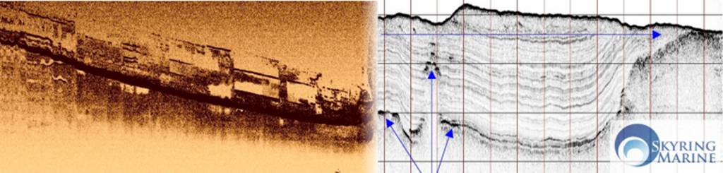
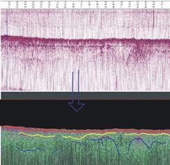
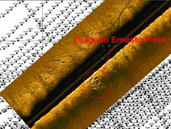
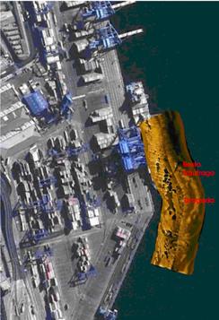
Experience and a brief description of some of the projects involved:

· Levantamiento geofísico marino con sub bottom profiler  (SBP) en trazados de  Bocatoma y Emisario para identificación de Roca madre Planta Punta Pereira. Montes del Plata, Uruguay. Enero 2012.

· Levantamiento geofísico marino con SBP y SSS para determinación de ubicación y profundidad de enterramiento de ex-Draga “Boston”. Terminal Marítimo San Vicente, ENAP. Mayo 2011, Abril 2012.

· Levantamiento geofísico marino con SBP para determinación de roca basal en ATI, Antofagasta. Raúl Pey y Cia. Mayo 2011.

· Levantamiento geofisico marino utilizando SBP  y SSS en búsqueda de roca basal y arqueología submarina en proyecto emisario submarino planta Valdivia. Celulosa Arauco y Constitución SA.

· Rebúsqueda de objetos extraviados de Base Naval de Talcahuano post terremoto. Marzo 2010.


· Rebúsqueda de avioneta siniestrada en Lago Villarica, Mayo 2010.


·  

Contact info:

Prat 725 of. 408

Valparaíso

Chile

p. +56(32)2214212

f. +56(32)2592992

m. +56(99)2755509

info@skyringmarine.cl

Teléfono: +56(32)2214212

Mobil: +56(99)2755509

Fax: +56(32)2592992

Correo: info@skyringmarine.cl